HEN GAER, HILLTOP ENCLOSURE
Description
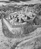
Photographic copy of conjectural reconstruction drawing of Hen Gaer Hillfort, Bow Street, produced as a private commission by Dylan Roberts, 1980.
Hen Gaer is a strong and imposing fortress, commanding panoramic views over the lowland basins north of the Rheidol, north to Caer Pwll Glas and beyond to the Dyfi Estuary. The fort is of massive construction. Carefully laid stone blocks of original rampart walling can be seen exposed on the northeast side. The rampart measures about 12m wide overall and still stands in places to a height of 3-4m (Hogg and Davies, Cardiganshire County History 1994, 264), with an outer rock-cut ditch (best visible on the northeast). The original main entrance appears to lie on the west side, and has a circular mound outside resembling a Roman titulum, which Hogg and Davies (1994, 264), says 'seems likely to be merely spoil from cutting a modern gap'. It is impossible to be certain without excavation, but the apparent authenticity of the gap in the rampart as a gateway suggests it could be an original defensive feature. As such it would be unique in Ceredigion, and probably in Wales.
Hen Gaer is unusual in that part of the rampart encloses a considerable hillslope to the south, avoiding a more level summit position to the north, which must have made the construction of houses in the southern part very difficult. One possible explanation of this non-utilitarian siting is that the fort had a role to command the ridge, but also to exert a degree of influence over, and to remain highly visible from, the restricted lowland basin at the confluence of the Afon Stewi and Silo to the south.

More items with these tags
Related items


Contact Us
To request take down or report racist, offensive or otherwise harmful content.

You must be logged in to leave a comment