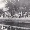
Land Use: Rural Depopulation (Talybont on Usk)
According to tithe maps and schedules with data from deeds from 1839 there were 38 named agricultural holdings in the Caerfanell and Clydach valleys where they met at Aber village. Cottages and dwellings did not have recorded names and were just given numbers on the census returns and are not shown on the maps. The Newport water schemes of 1926 followed by 1932 in the Caerfanell valley meant that the whole catchment area was acquired not just land to create the reservoir. Today the valley sides are coniferous plantations, the reservoir covers most of the best land and the rest of the fields are leased to one farmer. The Clydach valley too has seen drastic reductions having only one small holding remaining with a farmstead attached. The rest of the land is either forestry or accommodation land (three distant owners and no usable buildings). Other reasons for depopulation were slumps in farming generally especially in the 1920’s, landlords wanting to create larger holdings and industrial employment that offered a better income than a subsistence life on a marginal small holding. in 2020 nineteen dwellings remain occupied with 51 inhabitants. In addition there are 12 second homes or rentals.

More collections with these tags
Related items


Contact Us
To request take down or report racist, offensive or otherwise harmful content.

You must be logged in to leave a comment