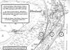
1900 Ordnance Survey Map of Blackmill
Description
Blackmill was first recorded in 1579, since then it has evolved around the confluence of the two Ogwr Rivers, the junction of two main roads and three railway lines, and can be considered the ‘Gateway to the Ogmore valleys.
External source:

This item also appears in

Contact Us
To request take down or report racist, offensive or otherwise harmful content.

You must be logged in to leave a comment