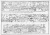
Cowbridge OS map of 1972
Description
Cowbridge OS map of 1972
Showing Westgate, High Street and Eastgate (with burgage plots) in three sections
[Publisher: Ordnance Survey ]
[Document ]

This item also appears in

Contact Us
To request take down or report racist, offensive or otherwise harmful content.

You must be logged in to leave a comment