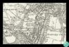
Extract from Ordnance Survey map Glamorgan sheet XVIII, 1885, showing location of first Pontypridd Synagogue
Description
Extract from Ordnance Survey map Glamorgan sheet XVIII, surveyed 1873-74, published 1885, six inches to the mile, showing the location of the first Pontypridd Synagogue.
The first Pontypridd Synagogue was founded in 1867, in a converted schoolroom. The address never seems to have been confirmed in print, and this Ordnance Survey map is the only authoritative source for its location.
The Jewish community dates back to at least the 1840s. Although the membership of the congregation remained small, they established their own section in the Glyntaff Cemetery in the 1890s and built a synagogue in Cliff Terrace, Treforest in 1895. The congregation was dissolved in 1978 and the synagogue was sold and converted to flats.
Reproduced with the permission of the National Library of Scotland.
The History of the Jewish Diaspora in Wales' by Cai Parry-Jones (http://e.bangor.ac.uk/4987).

More items with these tags
Related items


Contact Us
To request take down or report racist, offensive or otherwise harmful content.

You must be logged in to leave a comment