A Visit to Aberllynfi and Talgarth, Breconshire
Description
Photography by John Ball - 28 July 1999
(scanned from prints taken with a Sigma SA-300 35-mm SLR camera)
On a warm sunny day in July 1999, I undertook a photographic commission for a client in the USA, to illustrate two neighbouring parishes where his Breconshire ancestors once lived. The parishes were Aberllynfi on the south bank of the River Wye, and Talgarth at the western end of the Black Mountains. This Images of Wales feature is a record of my visit to these two Breconshire parishes. The first two pages focus on Aberllynfi, while the third is devoted to Talgarth.
Aberllynfi
Tallis's Topographical Dictionary of England and Wales (published in 1860) described the parish of Aberllynfi as comprising an area of 626 acres and having a population of 102 persons. In 1868, The National Gazetteer of Great Britain and Ireland provided a more detailed description (see also the GENUKI website):
ABERLLUNVEY, [Aberllynfi], a parish in the hundred of Talgarth, and union of Hay, in the county of Brecon, South Wales, 4 miles S.W. of Hay. It is situated at the confluence of the Llunvey [Llynfi] and the Wye. The parish is united with Glasbury, and is commonly considered a hamlet or chapelry thereto. There is no church. The inhabitants marry and bury at Glasbury, but they pay no church-rates. No tithes have been paid here within the memory of man. An old yew-tree tells where once a church stood, and persons lately living could recollect tombstones. The ground is now covered with fir-trees. Aberllunvey is on the south bank of the Wye, and in the midst of scenery beautiful and diversified.
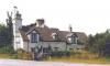
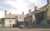
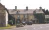
Image 1 and Image 2: The quaintly named Spread Eagle cottage.
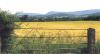
Image 3:
The Black Mountains dominate the skyline viewed from near Spread Eagle cottage.
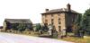
Image 4:
Pipton Farm.
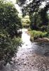
Image 5:
River Llynfi from the bridge near Pipton Farm.
The area around Spread Eagle cottage and Pipton Farm reveals considerable evidence of past religious activity, represented by buildings and other structures from the prehistoric period, and the early medieval to post-medieval periods. There is a group of Neolithic chambered long cairns at Pipton, and six Bronze Age ring-ditches near Spread Eagle cottage. This latter group appears to form part of a barrow cemetery, perhaps significantly sited on the edge of the floodplain near the confluence of the Llynfi and Wye. Evidence from crop marks suggests that the ring-ditches may form part of a complex which includes a Neolithic cursus monument represented by two parallel ditches. The purpose of cursus monuments is uncertain, but they appear to be associated with ritual activity.See the Clwyd-Powys Archaeological Trust (CPAT) website for a more detailed account.
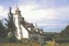
Image 6 and Image 7: The Three Cocks Hotel.
The hotel is believed to date from the 15th century, and for many years was a coaching inn on the main Brecon to Hereford road, now the A438.

More items with these tags
Contact Us
To request take down or report racist, offensive or otherwise harmful content.

You must be logged in to leave a comment