Abertillery, Monmouthshire

Description
Photography by John Ball - 18 Aug 1998 (with Agfa ePhoto-307 digital camera)
Abertillery is a former mining town, situated in the South Wales valley of the river Ebbw Fach. With the expansion in the mining industry in the 19th century, there was no alternative but to build terraces of workers' cottages higher and higher up the hillside. The pictures below illustrate the way the town spread up the east side of the valley.
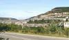
Image 1:
Looking northwards towards Abertillery from the A467 valley road.
The hill in the centre of the picture above marks the southern end of the Mynydd James ridge, and is known as the West Bank. The ridge separates the Ebbw Fach valley to the left, from the Cwm Tyleri valley on the right. Both valleys were once the site of intense coal mining activity, and a number of mining disasters including the explosions at the South Wales Pit in 1876 (20 killed), and the Tillery Colliery in 1874 (6 killed).
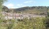
Image 2:
Terraces of workers' houses on the slopes of the 550 metre (1,800 foot) Gwastad.
Image 3:
A glimpse of Abertillery through the trees which line the valley.

More items with these tags
Contact Us
To request take down or report racist, offensive or otherwise harmful content.

You must be logged in to leave a comment