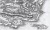
1in Ordnance Survey map of Penally Pembrokeshire
Description
Copy of 1in Ordnance Survey map showing the Tenby area noting the course of the railway to its pre 1866 terminus at the Salterns and embankment crossing Ritec estuary. 1 item

More items with these tags
Related items


Contact Us
To request take down or report racist, offensive or otherwise harmful content.

You must be logged in to leave a comment