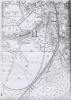
Ordnance Survey map of Ritec embankment Penally Pembrokeshire
Description
Copy of 2nd edition c.1907 Ordnance Survey Map enlarged and showing railway embankment and high tide point inland of the embankment. 1 item

More items with these tags
Related items


Contact Us
To request take down or report racist, offensive or otherwise harmful content.

You must be logged in to leave a comment