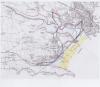
Map of the Tenby and Penally area 1969
Description
Copy Ordnance Survey map c.1969 showing the area of the Ritec Valley marshes with hand drawn amendments and areas of beach and inundation hand coloured . 1 item
More items with these tags
Related items


Contact Us
To request take down or report racist, offensive or otherwise harmful content.

You must be logged in to leave a comment