Criccieth – Names along the Shoreline
Description
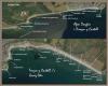
Criccieth Names along the Shoreline. The shore at Criccieth lies between two natural features: the mouth of the River Dwyfor and Black Rock to the east. The prominent headland on which the castle stands divides it into two sections. To the west it consists of rocky and pebbly beaches backed by boulder clay cliffs. At low tide bigger rocks and boulders are exposed. Immediately to the west of the castle rock is a stone breakwater which gives some shelter. Beyond the Victorian esplanade are more boulder clay cliffs. At low tide rocks are again exposed. There are sufficient clear areas either side of the castle to provide clear beaches for bathing and for the enjoyment of holiday makers. The material eroded away from these cliffs is swept eastwards by long shore drift to form a long shingle bank called the Heraig or Neraig. This bank has, over the centuries, blocked off an inlet to the sea, today called Llyn Ystumllyn (Ystumllyn Lake). The shingle bank comes to an abrupt end with the headland of Black Rock. Beyond is a long sandy beach. Here are some of the names found along the shoreline. They are all in Welsh and, as the aim of this project is to preserve these names they have not been translated. Most of the names are descriptive so we see: Cerrig = Stones or Rocks, Traeth = Beach, Glan y Môr = Seaside, Penrhyn = Promontory, Afon = River, Ogof = Cave.

More items with these tags
Related items


Contact Us
To request take down or report racist, offensive or otherwise harmful content.

You must be logged in to leave a comment