Cowbridge east side street map 1953
Description
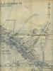
Cowbridge east side street map 1953
Showing the site of the planned council housing development, for example, dated 22nd May 1953. Cae Stumpie and Borough Close housing was started soon after this date.
[document 26x29]

Contact Us
To request take down or report racist, offensive or otherwise harmful content.

You must be logged in to leave a comment