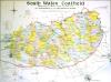
South Wales Coalfield map, c.1923
Description
Map of the South Wales Coalfield showing mineral takings of lessees of No 2 Rhondda and other bituminous seams. Published: The Business Statistics Publishing Company Limited, Scale: 1 mile to an inch. [c.1923]

More items with these tags
Related items


Contact Us
To request take down or report racist, offensive or otherwise harmful content.

You must be logged in to leave a comment