TURNPIKE and PRE-TURNPIKE ROADS: Medieval and Early Post-Medieval Sites Scheduling Enhancement Project (2014 Interim Report)
Description
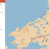
This interactive map has been created as part of a research initiative to explore in greater depth the findings of the TURNPIKE and PRE-TURNPIKE ROADS: Medieval and Early Post-Medieval Sites Scheduling Enhancement Project (2014 Interim Report), prepared by Dyfed Archaeological Trust for Cadw. The map serves to log and visualize data extracted from the report, including GPS coordinates and What3Words locations converted from the original OS Grid References. By integrating modern geospatial tools, this project aims to increase the accessibility, interpretive value, and public understanding of Wales’s historic transport infrastructure. Please note that this map is an ongoing project and is not yet complete. It is continuously being developed and is automatically updated as new data is added or refined. All data presented is based on the invaluable work of Dyfed Archaeological Trust, whose rigorous research and documentation form the foundation of this map. This project is intended as a dynamic resource to support further study, raise awareness of site preservation, and encourage wider public engagement with the rich history of Wales’s roads and travel networks.

Related items

Contact Us
To request take down or report racist, offensive or otherwise harmful content.

You must be logged in to leave a comment