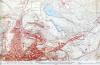
Map sahowing area of Dowlais ironworks 1851
Description
This is part of a public health map of 1851, showing Dowlais Ironworks (or the Ivor Works as it was then known) and the area around it at that time. It is interesting to note the various streets that are focussed around the Ironworks, as the primary employer of the area.

More items with these tags
This item also appears in

Contact Us
To request take down or report racist, offensive or otherwise harmful content.

You must be logged in to leave a comment