Wattstown: Landscape & History/Archaeology
Description
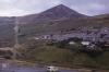
Picture: 1
Tylorstown Tip, Rhondda Fach. View from tops
Tylorstown tip and tramway from Wattstown, 1971
Date: 1971
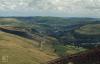
Picture: 2
Tylorstown Tip, Rhondda Fach. View from tops
Wattstown tip above Wattstown just South of Tylorstown. Ynyshir and Porth at junction of 2 Rhondda rivers
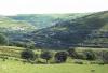
Picture: 3
Tylorstown Tip, Rhondda Fach. View from tops
View down Rhondda Fach to confluence with R. Fawr at Porth. Top right towards Tonyrefail is Rhiwgarn. Wattstown (left) Mid is Ynishir (Ynis is island, hir is something to do with water (?) between rivers
External source:

More items with these tags


Contact Us
To request take down or report racist, offensive or otherwise harmful content.

Comments (1)
Submitted by Angela Hughes on Mon, 18/03/2024 - 11:20
I would suggest the houses are part of Stanleytown and the photograph taken from the site of Tylorstown colliery with the route up to Tylorstown tip.
You must be logged in to leave a comment