: Map/Figure


Description
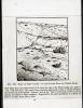
Picture: 1
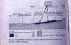
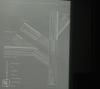
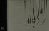
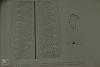
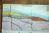
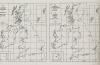
Machair. Profile after Whittow. Geol. + scen mseatd
Picture: 2
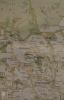
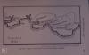
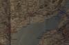
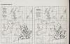
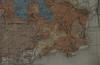
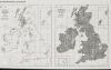
Map. Hebrides, Skye + W mainland
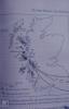
Picture: 3
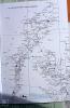
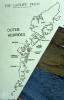
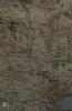
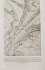
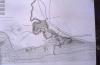
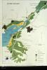
Map. The Uists
Picture: 4
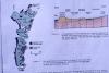
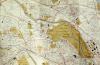
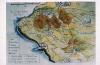
Relief map. Outer Hebrides + Skye.
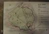
Picture: 5
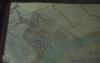
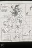
Outline map. Outer Hebrides
Picture: 6
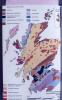
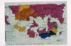
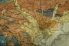
Geology map, Scotland
Picture: 7
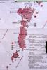
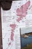
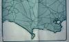
Outer Hebrides map
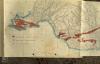
Picture: 8
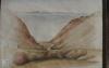
Barra dune and pasture Uist sands
Machair, map and profile after NCC
Picture: 9
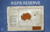
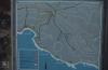
HANDA Island NW Scotland. Sea bird cliffs of N. June 1983
Map of Handa Island bird reserve off Sutherland, 766 acres.
Picture: 10
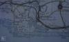
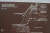
Blackweir to Western Ave
Map of Taff. Queen Street to Llandaff North
Picture: 11
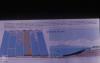
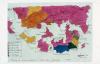
Physical and chemical factors of R Rhondda and R Cynon
Picture: 12
Substrate flow rate and algae. R Rhondda and R Cynon
Picture: 13
Acidity, O2 and suspended solids in R Rhondda
Picture: 14
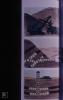
Aran Lecture
Aran stitches
Picture: 15
Maps. South Border Ridge. Llantrissant to Draethen
Map of coast of Vale of Glamorgan, Port Talbot, Barry
Picture: 16
Vale of Glamorgan. Maps/Geology
Soil map of the Vale of Glamorgan
Picture: 17
Vale of Glamorgan. Maps/Geology
Map. National Parks of Wales and Areas of Outstanding Beauty
Picture: 18
Lavernock locality
Map. Lavernock, Cosmeston, Reserve only. West
Picture: 19
Llantrithydd Place
Old drawing of Llantrithydd Place from M. Robins' thesis
Picture: 20
Maps River Taff
Map of upper taff Vale
Picture: 21
Maps River Taff
Map of lower Taff Vale
Picture: 22
Maps River Taff
Diagram of Taff river system
Picture: 23
Maps River Taff
Map of Upper Boat, Nantgarw, Graig yr Allt
Picture: 24
Maps River Taff
Taff Vale project Rubbish clearance August 1971. Willowford, gedrys
Date: 1971
Picture: 25
Taff Maps diagrams
Fish distribution in River Taff system
Picture: 26
Taff Maps diagrams
Map possible salmonoid spawning grounds River Taff 1983
Date: 1983
Picture: 27
Taff Maps diagrams
Sewin size in River Taff most are around one foot long 1983
Date: 1983
Picture: 28
Taff Maps diagrams
Invertebrate animals in Taff river system
Picture: 29
Geographical sections through coalfield
Geological section - Merthyr, Rhondda, Vale (and Beacons) Taff Fechan north limestone outcrop
Picture: 30
Geographical sections through coalfield
Geological section through North scarp Brecon Beacons
Picture: 31
Geographical sections through coalfield
Geology. Terminal recessional moraines in South Wales
Picture: 32
Coal formation diagrams
Types of coal mined in South Wales
Picture: 33
Coal formation diagrams
Formation of coal growth and subsidence of swamp forests
Picture: 34
Coal formation diagrams
Diagram. Formation of coal measures in seams
Picture: 35
Coal formation diagrams
3 mining methods. Opencast, horizintal and vertical shafts
Picture: 36
Coal formation diagrams
Pteridophytes. Diagram of relationships of groups
Picture: 37
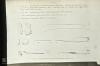
Calamites
Calamites. Reconstruction of giant horestail
Picture: 38
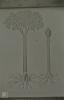
Stigmaria, Lepidodendron, Sigillaria
Horestails. Diagram of relationship with calamites
Picture: 39
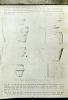
Stigmaria, Lepidodendron, Sigillaria
Lepidodendron and sigillaria. Reconstruction
Picture: 40
Stigmaria, Lepidodendron, Sigillaria
Cone of lepidostrobus (similar to selaginella)
Picture: 41
Llanwonno Parsleyfern, St Gwynno's Church
Cryptogramma, Northwest Adiantum Southwest Anagrama
Picture: 42
Lower Cynon Valley. Abercynon to Phurnacite plant
1873 map of Abercynon - then navigation
Picture: 43
Lower Cynon Valley. Abercynon to Phurnacite plant
Acidity, Oxygen, Suspended solids in River Cynon
Picture: 44
Llyn Fach, Fossil trees and drowned hut circle
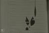
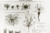
Isoetes habit and spores
Picture: 45
Coalfield ferns and co. Llanwonno, Rhondda
T.S. tree trunk diagram with dates (850 years)
Picture: 46
Severn. Geology
Map of Wentloog Levels, Cardiff-Newport
Picture: 47
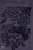
Bird, toad, slow worm, frog spawn
Blackbird/Elderberry sketch. 'Countryman'
Picture: 48
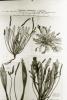
Mercury, spurge
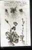
Morphological variation in Plantago coronopus var maritima
Marys species name: Plantago coronopus var maritima
Scientific name: Plantago coronopus
Common name: Buck's-horn Plantain
Picture: 49
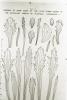
Mercury, spurge
Plantago coronopus var maritima leaf variation, Grassholm
Marys species name: Plantago coronopus var maritima
Scientific name: Plantago coronopus
Common name: Buck's-horn Plantain
Picture: 50
Plantains, Polygonum
Plantago coronopus, variation, Skokholm.
Marys species name: Plantago coronopus
Scientific name: Plantago coronopus
Common name: Buck's-Horn Plantain
Picture: 51
Primula, Gentian
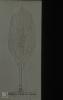
Samolus valerandi
Picture: 52
Mouth of River Thaw, 1622 field system. Manor of Funmun. (Marg. Davies, Transactions of Cardiff Naturalists Society)
Picture: 53
Map of Aberthaw. One inch OS before power station
Picture: 54
Aberthaw bee orchids
Bee orchid quadrat map, Aberthaw
Picture: 55
INTRO. Habitats and maps
1600 map of Vale of Glamorgan absentee landlords (M Robins PhD thesis)
Picture: 56
INTRO. Habitats and maps
1600 map of Vale of Glamorgan absentee landlords (M Robins PhD thesis)
Picture: 57
INTRO. Habitats and maps
Map of Aberthaw before canalisation of River
Picture: 58
INTRO. Habitats and maps
Aberthaw, map of estuary. 1950s
Picture: 59
INTRO. Habitats and maps
Geology map, mouth of Thaw. Deposits.
Picture: 60
INTRO. Habitats and maps
Surface geology of Cowbridge
Picture: 61
Cwm Bach Stream
1600 map of Ogmore - Dunraven from M Robin's thesis
Picture: 62
South Wales geology. Block diagram
Picture: 63
Draethen. Cwm Leyshon woodland reserve
Coed Cefn Pwll Ddu and Cwn Lleyshon map
Picture: 64
Little Garth Maps. Taff Gorge geology
Map. Little Garth, Tongwynlais, Radyr
Picture: 65
Little Garth Maps. Taff Gorge geology
Proposed SSSI boundary. Little Garth beechwood, October 1972
Picture: 66
Little Garth Maps. Taff Gorge geology
Map of beech as a native (from Hyde 1961, Welsh Timber Trees, Cardiff)
Picture: 67
Flatholm 1st rejects
Flatholm map. Paths and buildings
Picture: 68
River Rumney MAPS
Vegetation map. Saltmarsh outside Rumney at wharf. November 1978
Date: November 1978
Picture: 69
River Rumney MAPS
Map of Severn Estuary. Land below 50 ft.
Picture: 70
Lamby new lake, 2002
Map, Rumney mouth after cutting of 3rd loop by A48 in 1978
Date: 1978
Picture: 71
Lamby new lake, 2002
Map, River Rumney in 1950-60s, when no loops cut off.
Date: 1950-1960
Picture: 72
Maps
Little Garth cave. Finds of flint and bone objects
Picture: 73
Maps
Little Garth cave. Finds of Bronze Age pottery
Picture: 74
Melingriffith feeder and pump. Renovation. 1983
Processes in steel and tin plate workks. Melingriffith
Picture: 75
Map of M4 and canal nature reserve. Tongwynlais. 1983
Date: 1983
Picture: 76
Tongwynlais reserve in the making. 1976. M4 Reserve
Tongwynlais Canal. Landscape drawing of new reserve between two roads.
Date: Summer 1974
Picture: 77
Map of Whitchurch canal reserve and Long Wood
Picture: 78
Canal Excavations. Sewer Access Road and Motorway.
Whitchurch Canal. Embankment of M4 and Forest Farm. Access to factories. Plan. 1974
Picture: 79
Arrowhead
Sagittaria and Butomis S.E. distribution
Picture: 80
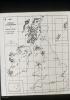
Ailsa Craig, Sula Sgeir
Map of Scotland and Isles, 'Devonia', 1966
Date: 1966
Picture: 81
Bamburgh, N'umbs and Saltings sunsets
Map Northumbs Farnes - St Abbs
Picture: 82
Lindisfarne Priory
Map of Berwick, Farnes, St Abbs Head
Picture: 83
East Lulworth cliffs and flowers, people and rocks
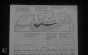
Map. Geology of Lulworth Cove
Picture: 84
Kimmeridge Bay just before deepening of oil well in 1980
Map of Kimmeridge area, Dorset Heritage Coast
Picture: 85
Abbotsbury Tithe Barn and Pond, 1980
The Fleet. Written description.
Picture: 86
Outline map of Dorset Coast
Picture: 87
Camm system Chesil, Can gully.
Picture: 88
Inward movement of beaches to land
Picture: 89
Dyke swarm radiating from Mull and Skye, Scotland
Picture: 90
Flatholm map. Prinicpal features.
Picture: 91
Carboniferous Minerals
Map of carboniferous limestone and caboniferous and lias quarries, Glamorgan
Picture: 92
Views from Penarth Head and over Cardiff Bay
Geology. Map, Barry, Penarth, Wenvoe
Picture: 93
Geology map of Cardiff
Picture: 94
Rhaetic fossils and pyrites. Westbury on Severn
Geological section, AUST cliff - as seen from M4 bridge
Picture: 95
St Donats Castle, West wood flowers and fish ponds
1776 engraving of Stradling Tower, St Donats from the St Donats History. 1983
Picture: 96
Cwm Nash tufa infill, Monknash
Monknash Valley, 26/09/1876
Picture: 97
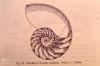
Nautilus pompileus. Section of spiral shell
Marys species name: Nautilus pompileus
Picture: 98
Seaweeds
Diagram. Fucus serratus, ceranoides and table of Fucus characters
Marys species name: Fucus serratus
Scientific name: Fucus serratus
Common name: Serrated Wrack
Picture: 99
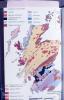
Geology map. Scotland
Picture: 100
Llyn Fach, Rhondda
Drawing of coal forest. Sigillaria, Calamites, etc
Picture: 101
Llyn Fach, Rhondda
Lobelia dortmanna, north west distribution
Picture: 102
Llyn Fach crags. Rhigos 1972
Three isoetes (quillwort) species. North west distribution
Picture: 103
Llyn Fach crags. Rhigos 1972
Hymenophyllum wilsonii. North west distribution and bracken
Picture: 104
Llyn Fach crags. Rhigos 1972
Lycopodium selago. Increasingly north west distribution

More items with these tags
Related items


Contact Us
To request take down or report racist, offensive or otherwise harmful content.

You must be logged in to leave a comment