Rudry: Map/Figure & Geology
Description
Picture: 1
Maps. South Border Ridge. Llantrissant to Draethen
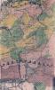
Rudry Common. Map of agricultural land classification
Picture: 2
Maps. South Border Ridge. Llantrissant to Draethen
Geological transverse section of Rudry-Cefn On
External source:

More items with these tags
Related items


Contact Us
To request take down or report racist, offensive or otherwise harmful content.

You must be logged in to leave a comment