Lavernock: Map/Figure
Content can be downloaded for non-commercial purposes, such as for personal use or in educational resources.
For commercial purposes please contact the copyright holder directly.
Read more about the Creative Archive Licence.
Description
Penarth Front
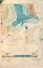
Lavernock Point and map. Geology cross section, 1982
Date: 1982
External source:
Date Joined:
19/06/2017
Owner:
South East Wales Biodiversity Records Centre (SEWBReC)
Creator:
Dr Mary Gillham
License information:
Copyright Details:
Dr Mary Gillham 2017
Item uploaded:
27/11/2017
Views:
237
Favourites:
0
More items with these tags
Related items
-
St. Mary Wells Bay, Lavernock
Type ItemUploaded by Vale of Glamorgan Libraries -
St Mary's Well Bay, Penarth
Type ItemUploaded by Vale of Glamorgan Libraries -
St Mary's Well Bay, Lavernock
Type ItemUploaded by Vale of Glamorgan Libraries -
Porpoise off Penarth - Article from the Evening Express, 1909
Type ItemUploaded by Living Seas Wales -
Cliff Walk looking to Lavernock, Penarth
Type ItemUploaded by Llyfrgell Genedlaethol Cymru / The National Library of Wales -
Lavernock: History/Archaeology & Geology
Type ItemUploaded by 'A Dedicated Naturalist', the Mary Gillham Archive Project -
Lavernock: Invertebrate
Type ItemUploaded by 'A Dedicated Naturalist', the Mary Gillham Archive Project -
Lavernock
Type ItemUploaded by 'A Dedicated Naturalist', the Mary Gillham Archive Project -
Lavernock: Landscape & Water
Type ItemUploaded by 'A Dedicated Naturalist', the Mary Gillham Archive Project -
Lavernock: Geology & Plant/tree
Type ItemUploaded by 'A Dedicated Naturalist', the Mary Gillham Archive Project
Contact Us
To request take down or report racist, offensive or otherwise harmful content.
You must be logged in to leave a comment