Penarth, Vale of Glamorgan: Landscape


Description
Picture: 1
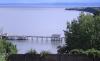
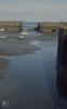
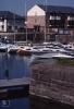
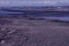
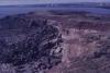
Penarth Front
Penarth Pier and Lavernock Point from Penarth Head 2000 (duplicate)
Date: 2000
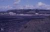
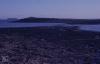
Picture: 2
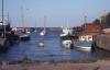
Penarth Front
Ships and Holms. Lower Penarth Cliffs, 16/08/78
Date: 16/08/1978
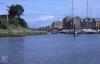
Picture: 3
View up Ely from Penarth old inner dock to Taff Gorge. Old road down. 04/08/00
Date: 04/08/2000
Picture: 4
Penarth. Ely. New Dock Road. Old wharf and warehouse, 04/08/00
Date: 04/08/2000
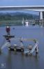
Picture: 5
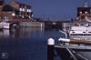
Penarth Docks
Loading bays. Penarth middle dock. West side, 1979
Date: 1979
Picture: 6
Outer Penarth Dock at low water looking seaward, September 1974
Date: September 1974
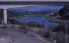
Picture: 7
Cardiff Bay barrage from above Penarth Marina. Curves in leaving Alexandra Dock lock open to sea. August 2000
Date: August 2000
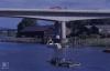
Picture: 8
Cardiff Bay from Penarth old red docks office centre. Craig Llanishen in distance from road below High View Road, August 2000
Date: August 2000
Picture: 9
Ely mouth and Cardiff Bay 2000
Moored boats, East bank of River Ely against Ferry Road, 04/08/00
Date: 04/08/2000
Picture: 10
Ely mouth and Cardiff Bay 2000
Yachts to seaward of Penarth Marina from boat, 24/02/01
Date: 24/02/2001
Picture: 11
Ely mouth and Cardiff Bay 2000
Ely mouth, Mayweed. Victoria Wharf opposite Cogan Spur crossing, 14/08/01
Date: 14/08/2001
Picture: 12
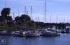
Penarth Dock (inner and middle doacks West of Taff-Ely basin)
Penarth middle dock view from old loading bay to open way to outer dock basin. 26/05/90
Date: 26/05/1990
Picture: 13
Penarth Dock (outer) with and without ice
High tide in outer dock, Penarth, May 1984
Date: May 1984
Picture: 14
Penarth Dock (outer) with and without ice
Inside of Penarth marina sea lock. Closed at low water. Clinically clean, no plant in sight. 26/05/90
Date: 26/05/1990
Picture: 15
Penarth Dock (outer) with and without ice
Outside Penarth sea lock, low water. 26/05/90
Date: 26/05/1990
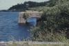
Picture: 16
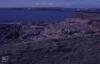
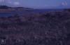
St Marywell Bay. Boxing Day 1980
Date: 26/12/1980
Picture: 17
Sully Island Maps
Sully Hospital from South West corner of Sully Island. November 1986
Date: November 1986
Picture: 18
Sully Island Maps
Sully Island causeway from summit of island to south east. November 1986
Date: November 1986
Picture: 19
Sully Island Maps
North east scrub Sully Island. View to Lavernock Point. November 1986
Date: November 1986
Picture: 20
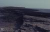
Sully Island Causeway
Sully Island Causeway and West scrub. May 1967
Date: May 1967
Picture: 21
Sully Island Causeway
Causeway and Swanbridge from west side of Sully Island. 1986
Date: 1986
Picture: 22
Sully Island Causeway
South West Sully Island. Barry and Sully Hospital. 15th November 1986
Date: 15/11/1986
Picture: 23
Sully Island North beach. Wreck. Horned Poppy
Tide meets over Sully Island Causeway. November 1986
Date: November 1986
Picture: 24
Dinosaur footprints Sully, Bendricks (Barry)
Swanbridge Farm from causeway to Sully Island. 1986
Date: 1986

More items with these tags
This item also appears in

Contact Us
To request take down or report racist, offensive or otherwise harmful content.

You must be logged in to leave a comment