Glamorgan: Map/Figure
Description
Picture: 1
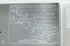
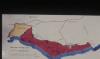
Vale of Glamorgan. Maps/Geology
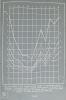
Rainfall graphs Glamorgan
Picture: 2
Vale of Glamorgan. Maps/Geology
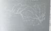
Mid Glamorgan coastline
Picture: 3
Vale of Glamorgan. Maps/Geology
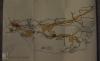
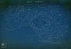
Regions of Glamorgan (Coalfields)
Picture: 4
South Limestone quarrying ext. areas. Glamorgan, January 1975
Date: January 1975
Picture: 5
Map fo Glamorgan Heritage Coast
Picture: 6
Graig Wen. Pontypridd. Farm > Coal
Rainfall map of Glamorgan 1960 County History.
Date: 1960
External source:

More items with these tags
Related items


Contact Us
To request take down or report racist, offensive or otherwise harmful content.

You must be logged in to leave a comment