St Mary's Well Bay: Landscape

Description
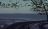
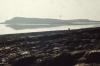
Picture: 1
St Mary's Well Bay
Marywell Bay looking Southeast. Seaward curves on beach and Steepholm Island. May 1967
Date: May 1967
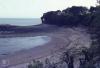
Picture: 2
St Mary's Well Bay, Trias Point with house and wood
St Mary's Well Bay from East cliff. Wall intact under house in May 1967. 16 years later there has been several breaches
Date: 1983
Picture: 3
St Mary's Well Bay
Sully Island and St Mary's Well Bay from sea, Margherita to Flatholm, October 1975
Date: October 1975
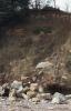
Picture: 4
St Mary's Well Bay. Sea algae and marine fauna
Recent fall of Keuper red sandstone. West of St Mary's Well Bay, January 1983
Date: January 1983
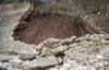
Picture: 5
St Mary's Well Bay. Sea algae and marine fauna
Collapsed wall East of St Mary's Well Bay House. Trias soil. January 1983
Date: January 1983
Picture: 6
Sully Island
Foreshore West of St Mary's Well Bay and Sully Island

More items with these tags
Related items


Contact Us
To request take down or report racist, offensive or otherwise harmful content.

You must be logged in to leave a comment