Penarth, Vale of Glamorgan: Geology & Landscape
Description
Picture: 1
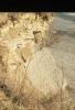
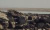
St Mary's Well Bay
White Lias slabs. Cliff West of Penarth, March 1973
Date: March 1973
Picture: 2
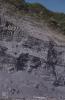
Views from Penarth Head and over Cardiff Bay
Heap of crumbled shale east of Lavernock. Lower Penarth
Picture: 3
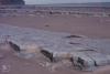
Lavernock Geology cliff and beach platform shale bands and clay mud
Lias Beach, shale under sandstone surface. West of Lavernock Point. August 1978
Date: August 1978
Picture: 4
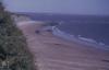
Lavernock Geology cliff and beach platform shale bands and clay mud
Bristol Channel sands below the Jurassic Cliffs of Lavernock Reserve. Lavernock Point, horizon, bedding, storm beach.
Picture: 5
St. Mary's Well Bay. Lias cliffs in East.
Outcrop on beach platform. St Mary's Well bay.

More items with these tags
Related items


Contact Us
To request take down or report racist, offensive or otherwise harmful content.

You must be logged in to leave a comment