Gileston: Landscape & Industry


Description
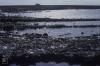
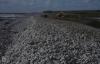
Picture: 1
Gileston pebble beach. 4. Closed sward behind beach
Gileston power station at high water. Heritage Coast. October 1975
Date: October 1975
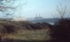
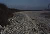
Picture: 2
Gileston. Ancient pebble and sand ridges.
View across four beach ridges pointing inland. Gileston, 07/10/81
Date: 07/10/1981
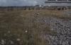
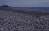
Picture: 3
Walls Pond. Limperts Bay, Gileston
Gileston, Oblique ends of old beaches engulfed by new ice. 02/01/80
Date: 02/01/1980
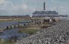
Picture: 4
Breaksea Point. Algae
Permanent pool, Breaksea Point power station intake of cooling water, October 1982
Date: October 1982
Picture: 5
Cliff scrub between Summerhouse Point wood and Gileston Beach, 1976
Date: 1976
Picture: 6
Gileston Farm and Manor from storm beach
2 incurved beaches near Gileston, East end. October 1981
Date: October 1981
Picture: 7
West Gileston Beach rocks of backing clifflet, 1984. Clay breakdown
Drainage of Walls pond, Limperts Bay, 07/10/81
Date: 07/10/1981
Picture: 8
West Gileston Beach rocks of backing clifflet, 1984. Clay breakdown
Steep swash beach by Walls pond drainage scheme, October 1981
Date: October 1981
Picture: 9
West Gileston Beach rocks of backing clifflet, 1984. Clay breakdown
Steeply banked West end, Gileston Beach, January 1984
Date: January 1984
Picture: 10
West Gileston Beach rocks of backing clifflet, 1984. Clay breakdown
Gilestone. Wave-cut platform downshore under beach, June 1985
Date: June 1985

More items with these tags
Related items


Contact Us
To request take down or report racist, offensive or otherwise harmful content.

You must be logged in to leave a comment