Penarth, Vale of Glamorgan: Map/Figure

Description
Picture: 1
Lavernock Geology cliff and beach platform shale bands and clay mud
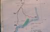
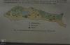
Lavernock Point Map. Position of Nature Reserve. December 1982
Date: December 1982
Picture: 2
Lavernock Geology cliff and beach platform shale bands and clay mud
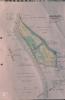
Lavernock Point map. Scrub - spread in reserve. 1980
Date: 1980
Picture: 3
Sully Island Maps
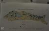
Sully Island map of vegetation. (Peter Ferns)
Picture: 4
Sully Island Maps
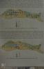
Sully Island map of Rabbits. (Peter Ferns)
Picture: 5
Sully Island Maps
Sully Island map of mice and voles (Peter Ferns)
Picture: 6
Sully Island Maps
Sully Island map of uncommon mammals (Peter Ferns)
External source:

More items with these tags
Related items


Contact Us
To request take down or report racist, offensive or otherwise harmful content.

You must be logged in to leave a comment