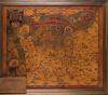
Tooled leather map of northern France, showing the Invasion Beaches of Normandy, made for the 49th Reconaissance Regiment, 1940s
Description
A tooled leather map of northern France, showing the invasion beaches of Normandy and the path taken by the 49th Reconaissence Regiment, who acted as Montgomery's left flank in the liberation of Europe.
The regiment was formed in Porthcawl in 1942 and disbanded in 1946. They regard Porthcawl as their home, and the museum holds the regimental memoribilia for safekeeping.
This item also appears in

Contact Us
To request take down or report racist, offensive or otherwise harmful content.

You must be logged in to leave a comment