The Lost Road of Talley.
Description
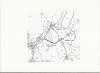
When David Long - Price wrote his history of Talley Abbey in 1879, he described the limits of the Abbey grounds and identified the south western gate as being in the field known as Cae y Porth. He describes the old high road, “Old London Road” running round the edge “now closed”. An extract of a tithe map dated 1839 shown here clearly shows this 'Old London Road' as part of the old network which ran through and around the old village.
We can see how the road would have emerged right where the village notice board now stands, tying in with the existence of a mill somewhere along the small stream which emerges at this point.
An abridged version of an article in Y Llychau.

More items with these tags
Contact Us
To request take down or report racist, offensive or otherwise harmful content.

You must be logged in to leave a comment