Photographs of Gwauncaegurwen 13
Description
Gwauncaegurwen
These photographs contributed by Graeme and Gwen Wells of New Zealand (Jan 2005)
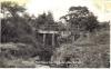
1.Pont Bara-Ceirch, near Cwmbach
Pont Bara-Ceirch was obliterated by the coal tip that also destroyed the Maerdy cottages An interesting name, meaning Oatcake Bridge
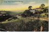
2.Graig Road, marked 1908
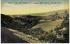
3.Graig Road and Valley from Bettws Side
4.Maerdy Tip looming large over Colbren Square
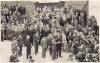
5.Field Marshall Montgomery at Steer Pit during his tour of South Wales in 1947 - with Dan Lloyd of Colbren Square leading the GCG Band
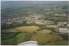
6.An aerial view of GCG looking N.E.E.- the village and general area Photograph by Paul Bennett of Llandilo who piloted the plane The straight line in the bottom half is the railway line from GCG to Abernant. Other features include the trotting track and Tairgwaith top right, the open cast works centre top and Brynamman top left.
See profile page for copyright and acknowledgements.

This item also appears in

Contact Us
To request take down or report racist, offensive or otherwise harmful content.

You must be logged in to leave a comment