Details from an archaeological desk based assessment of Pembrokeshire
Content can be downloaded for non-commercial purposes, such as for personal use or in educational resources.
For commercial purposes please contact the copyright holder directly.
Read more about the Creative Archive Licence.
Description
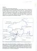
Details of a desk based archaeological assessment of Pembrokeshire with a map showing of HER points relating to World War 1 sites and structures
Uploaded by
Date Joined:
03/03/2021
Item uploaded:
29/3/2021
Views:
174
Favourites:
0
More items with these tags
Related items
-
Welsh Fortresses Through Time — 186 Sites Across Three Thousand Years of Fortress-Building in Wales
Type ItemUploaded by Graham T Emmanuel -
A Timeline of Conflict in Wales 616–1421 AD — Complete Historical Narrative Companion
Type ItemUploaded by Graham T Emmanuel -
The Mills of Wales — Wind, Water and Tidal Heritage: A Complete Survey of 84 Historic Mill Sites
Type ItemUploaded by Graham T Emmanuel -
Oes y Sant — The Age of the Saints: An Interactive Map and Companion Guide to the Sacred Landscape of Wales, c. AD 450 to 600
Type ItemUploaded by Graham T Emmanuel -
War Memorial Ledger for West Walesl-QR‑Coded
Type ItemUploaded by Graham T Emmanuel -
Merched Beca — The Rebecca Riots of West Wales 1839–1844 — An Interactive Heritage Map and Digital Archive
Type ItemUploaded by Graham T Emmanuel -
Turnpike Roads of South-West Wales · Milestones, Toll Gates and Lost Infrastructure 1700–1844
Type ItemUploaded by Graham T Emmanuel -
Invoice from J W Thomas & Sons, Llandeilo, 13 August 1965
Type ItemUploaded by Hengwrt -
Bosherston 1841 Census Charts
Type ItemUploaded by Chris Ball -
Pen-y-Holt stack
Type ItemUploaded by Chris Ball
Contact Us
To request take down or report racist, offensive or otherwise harmful content.
You must be logged in to leave a comment