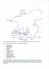
Document showing the sites in Pembrokeshire taken from Roger Thomas' survey of 1993
Content can be downloaded for non-commercial purposes, such as for personal use or in educational resources.
For commercial purposes please contact the copyright holder directly.
Read more about the Creative Archive Licence.
Description
Map and legend showing sites taken from Roger Thomas' survey of 1997 and detailing their categories
Uploaded by
Date Joined:
03/03/2021
Item uploaded:
29/3/2021
Views:
197
Favourites:
0
More items with these tags
Related items
-
War Memorial Ledger for West Walesl-QR‑Coded
Type ItemUploaded by Graham T Emmanuel -
Merched Beca — The Rebecca Riots of West Wales 1839–1844 — An Interactive Heritage Map and Digital Archive
Type ItemUploaded by Graham T Emmanuel -
Turnpike Roads of South-West Wales · Milestones, Toll Gates and Lost Infrastructure 1700–1844
Type ItemUploaded by Graham T Emmanuel -
Invoice from J W Thomas & Sons, Llandeilo, 13 August 1965
Type ItemUploaded by Hengwrt -
Bosherston 1841 Census Charts
Type ItemUploaded by Chris Ball -
Pen-y-Holt stack
Type ItemUploaded by Chris Ball -
Building Slip
Type ItemUploaded by Chris Ball -
New Quay
Type ItemUploaded by Chris Ball -
St Mary's Church, Pwllcrochan
Type ItemUploaded by Chris Ball -
Carew Castle in Red
Type ItemUploaded by Chris Ball
Contact Us
To request take down or report racist, offensive or otherwise harmful content.
You must be logged in to leave a comment