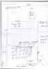
Map of Hearson Camp Sardis Pembrokeshire
Content can be downloaded for non-commercial purposes, such as for personal use or in educational resources.
For commercial purposes please contact the copyright holder directly.
Read more about the Creative Archive Licence.
Description
A brief hand drawn map of Hearson Camp Pembrokeshire showing some aspects of the camp including the exercise area, officers amenities and the underground trenches.
Uploaded by
Date Joined:
03/03/2021
Item uploaded:
29/3/2021
Views:
303
Favourites:
0
More items with these tags
Related items
-
War Memorial Ledger for West Walesl-QR‑Coded
Type ItemUploaded by Graham T Emmanuel -
Merched Beca — The Rebecca Riots of West Wales 1839–1844 — An Interactive Heritage Map and Digital Archive
Type ItemUploaded by Graham T Emmanuel -
Turnpike Roads of South-West Wales · Milestones, Toll Gates and Lost Infrastructure 1700–1844
Type ItemUploaded by Graham T Emmanuel -
Invoice from J W Thomas & Sons, Llandeilo, 13 August 1965
Type ItemUploaded by Hengwrt -
Bosherston 1841 Census Charts
Type ItemUploaded by Chris Ball -
Pen-y-Holt stack
Type ItemUploaded by Chris Ball -
Building Slip
Type ItemUploaded by Chris Ball -
New Quay
Type ItemUploaded by Chris Ball -
St Mary's Church, Pwllcrochan
Type ItemUploaded by Chris Ball -
Carew Castle in Red
Type ItemUploaded by Chris Ball
Contact Us
To request take down or report racist, offensive or otherwise harmful content.
You must be logged in to leave a comment