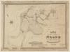
Tithe Map of Neath
Description
Tithe map of Neath
Acres: 1121
Tithe payments: £143 Parish. £143 Rector
Valuers : David Rees, Neath :: Alfred Wallace, Neath
Surveyor: David Rees, Neath
Scale: 1:6336
Class: 2nd
Tithe maps were produced between 1838 and 1850 following the Tithe Commutation Act of 1836 as a part of the process to ensure that all tithes were paid with money rather than produce. They are the most detailed maps of their period and there are over a thousand of them covering more than 95% of Wales.

This item also appears in


Contact Us
To request take down or report racist, offensive or otherwise harmful content.

You must be logged in to leave a comment