CASTLEMARTIN TRAINING AREA; CASTLEMARTIN RANGE
Description
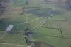
Aerial photograph of Castlemartin Training Area looking east and showing military roads and installations near Newton. Taken on 19 November 2005.
The Castlemartin Range is one of twelve Army Training Estates (ATEs) in the British Isles, covering some 6,400 acres of prime limestone coastal plateau. The principal assets of this landscape are the sheer cliffs of Carboniferous Limestone which form some of the most famous limestone coastal scenery in Britain. Wave action and weathering have exploited faults in the rock and carved out caves, fissures and blow-holes, which time and subsequent collapses have turned into glorious arches, like the Green Bridge of Wales, and free-standing stacks. While some visitors will survey the cliff lines looking at the dipping limestone strata or teeming colonies of guillemots and razorbills at Stack Rocks, archaeologists are more likely to be looking for the eroded remains of coastal promontory forts, like Flimston Bay fort, or traces of early settlement inland. In medieval times this land fell within the Marcher earldom of Pembroke, and remnants of the farms and hamlets originally settled by French, English and Flemings can still be seen at Flimston and Pricaston in the central and western parts of the range. Earlier still is St Govans chapel, a medieval rebuilding of an early Christian hermit's cell, built in a cleft between high coastal cliffs. This coastline has attracted early tourists and writers from the late seventeenth century, who were held in awe by the majestic scenery and ancient sites found along the cliffs.
In the twentieth century Castlemartin was requisitioned for military training along with other Welsh estates like Sennybridge in central Wales and the coastal ranges at Manorbier and Penally. The range was established in 1938 and used until 1945 for tank training by the Royal Armoured Corps. It was briefly returned to agricultural use after the war, but was acquired by the War Department in 1948 and pressed back into service in 1951 with the advent of the Korean War (1950-3). It remained as a specialist tank training range, often hosting German units, until 1995, when training activities were broadened to include infantry and small arms training. Against the background of the intensively farmed lowland landscape of South Pembrokeshire, the Castlemartin range now stands as a valuable microcosm of land which has never been subjected to the damaging advances of intensive agriculture or development. Despite the impact of military training, the archaeological, historical and ecological heritage survives largely intact.

Related items


Contact Us
To request take down or report racist, offensive or otherwise harmful content.

Comments (2)
Submitted by Adrian T A James on Fri, 30/06/2017 - 18:08
This photograph shows an Armoured Fighting Vehicle range, built in 1941, for the training of recruits into the Royal Armoured Corps. The triangular concrete track, which seems to have built in undulations, was designed to allow gunners to learn and practice their shooting technique at targets situated on St Govan's Head. A tank would drive around the track, giving the gunner the opportunity to engage targets from many different aspects. The targets included tank silhouettes that moved back and fore on a narrow gauge railway track. This allowed the gunner to learn how to "aim off" when trying to hit moving targets.
The large concrete hard standing was where the tanks were kept when not firing. There was a small camp with Nissen huts between this hardstanding and the valley to the north. Newton Farm, the site of which is just off shot to the left (north) was the officers mess. The range was little used after the end of the Second World War and eventually an aircraft rocket and strafing range was established, the control tower and briefing room for which can be seen in the top right of the photograph. The range was used to train pilots from RNAS Brawdy and RAF Chivenor in the 1950s and early 1960s. Latterly the range was used by Royal Navy helicopters, and the circular concrete pads (apart from the furthest from camera, which is an old tank turning circle from c1941) originate from this period.
In the centre of the photograph, just south of the original road to St Govans Head, is the site of a house that was known as Castle Tank.
Submitted by Royal Commissi… on Mon, 28/11/2016 - 09:15
Many thanks for adding this information - RCAHMW
You must be logged in to leave a comment