WAT'S DYKE: FROM SOUTH-EAST OF WHITEHOUSE FARM TO SOUTH-WEST OF GARREG LLWYD
Description
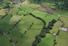
Aerial photograph of a section of Wat's Dyke from southeast of Whitehouse Farm to southwest of Garreg Llwyd. Taken on 30 July 2009.
External source:

More items with these tags


Contact Us
To request take down or report racist, offensive or otherwise harmful content.

You must be logged in to leave a comment