Llandow airfield, 1989
Description
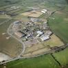
This aerial photograph showing the derelict Llandow airfield was taken in 1989 by Aerofilms Ltd.
Immediately after the end of the Second World War, RAF planes remained a familiar sight overhead as military photographers, using the reconnaissance skills learned during wartime recorded every part of Britain as part of 'Operation Revue', an aerial survey carried out for the Ordnance Survey. Running from 1945 to 1951 it served two purposes: employing pilots and aircrew in peacetime, and creating an up-to-date overview of what the whole of the country looked like, to help Government planners and architects to produce a vision for the future development of Britain.
After the war, Llandow airfield was used as a dispersal site for aircraft that were no longer needed after the end of the Second World War. Llandow coped with significantly more aircraft than expected for such a small establishment. By 1946 some 856 airframes were waiting to be scrapped, including bombers such as the Lancaster, Halifax, and Wellington, plus large numbers of Mosquito and Beaufighter fighter-bombers. Even iconic Spitfires could not escape being broken up for scrap.
The defences around the airfield included Picket-Hamilton forts. All the original buildings remain intact and are used for storage behind security fencing. The type 518/40 pattern control tower is now used as offices. The main runway forms a public road, with the B4270 using part of the perimeter track. A go-cart circuit also uses parts of the runways and the perimeter track.
Photo Ref:afl03_aerofilms_ac548699

More items with these tags
This item also appears in

Contact Us
To request take down or report racist, offensive or otherwise harmful content.

You must be logged in to leave a comment