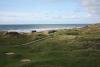
View from Range Finder near Moel Ynys
Description
The small hill behind Moel Ynyslas was used as a navigation mark and is shown with flagstaff on Lewis Morris's early Admiraly chart dating to 1740. When the Ynyslas was developed as a firing range, a brick platform was built and range finder installed looking out over the offshore range. The observation post and its accompanying BCF hut can be seen in the distance at the edge of the dunes.

More items with these tags
This item also appears in


Contact Us
To request take down or report racist, offensive or otherwise harmful content.

You must be logged in to leave a comment