BANGOR
Description
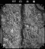
Digitized copy of an aerial photograph showing Upper Bangor area, taken by Ordnance Survey, 1994.
External source:

Contact Us
To request take down or report racist, offensive or otherwise harmful content.

You must be logged in to leave a comment