Caer Cadwgan; Caer Morys; Y Gaer; Gelli-gaer
Description
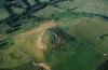
Slide of RCAHMW colour oblique aerial photograph of Caer Cadwgan, taken by C.R. Musson, 24/6/1989.
Caer Cadwgan is an oval enclosure, approximately 96m from north-east to south-west by 55m. It is defined by scree-like tumbled walls crowning a distinct hill above the Ffrwd Cynon valley. It also shows traces of a dividing wall, enclosing the higher, south-eastern part of the main enclosure. A less substantially defined outer circuit encloses an area about 60m across on the eastern and southern sides, with an entrance on the west, to the north of which is a possible oval banked and terraced enclosure, about 36m across, abutting the main circuit.
Excavations between 1984 and 1989 recorded details of a north-east facing entrance, subsequently blocked, and examined an area of the interior, with the remains of two circular structures, one of which was multiphase, its sequence interrupted by a four-post structure. Occupation may have extended into the Roman period, with subsequent re-use (or continuing use).
Sources: Burnham in UWL Caer Cadwgan interim reports, 1984-9;
Austin et al. 1988 Current Arch. 109, 51-4;
Davies & Hogg 1994 'Cardigan. County Hist. I', 257-8 fig 53;
see also - AW 24 (1984), 26-8; AW 25 (1985), 18.
The name Caer or Gaer Maurice appears on the Ordnance Survey 1st Series, dated 1834, "The History of Cardiganshire" by Samuel Rush Meyrick, (page 227), and Caer Morys in Annals and Antiquities of the Counties and County Families of Wales by Thomas Nicholas,1872, vol I, page 154.
More items with these tags
Related items


Contact Us
To request take down or report racist, offensive or otherwise harmful content.

Comments (2)
Submitted by EUROS on Fri, 16/12/2016 - 18:25
This is not Caer Cadwgan but locally known as Y Gaer and on old maps and books is known as Gaer Maurice, or Gaer Morys. Caer Cadwgan is a name place 400 yards to the west of here and is known to have been an encampment. It is only since the mid 1980's it has been mis-named. Note that it is not in Llanfair Clydogau but in the parish of Cellan
Submitted by EUROS on Thu, 01/12/2016 - 23:45
Dim Caer Cadwgan ond Y Gaer yw yr enw sydd ar y gaer yma heddiw gan bobl lleol. Yn yr hen ddyddiau ei enw oedd Gaer Morys- fel y dangosydd ar y mapiau cynnar. Mae Caer Cadwgan tua 400can llath i'r gorllewin or fan hyn ac yr ydym yn gwybod mae lluest oedd yno, ond mae'r enw caer-cadwgan yn cael ei ddefnyddio ar y ty yma. Ond ers 1980au mae Caer cadwgan wedi ei gamddefnyddio ar Gaer Morys. Nid yn Llanfair Clydogau ond yng Nghellan lleolwyd y Gaer
You must be logged in to leave a comment