South Wales: Map/Figure & Geology
Content can be downloaded for non-commercial purposes, such as for personal use or in educational resources.
For commercial purposes please contact the copyright holder directly.
Read more about the Creative Archive Licence.
Description
Picture: 1
Vale of Glamorgan. Maps/Geology
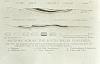
Geological sections across the South Wales coalfields
Picture: 2
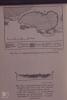
Geology of south Wales coalfield
External source:
Date Joined:
19/06/2017
Owner:
South East Wales Biodiversity Records Centre (SEWBReC)
Creator:
Dr Mary Gillham
License information:
Copyright Details:
Dr Mary Gillham 2017
Item uploaded:
27/11/2017
Views:
532
Favourites:
0
More items with these tags
Related items
-
War Memorial Ledger for West Walesl-QR‑Coded
Type ItemUploaded by Graham T Emmanuel -
Extract from colliery closure volume, 1948-1970
Type ItemUploaded by Glamorgan Archives / Archifau Morgannwg -
Extract from Schedule of Tips near Buildings concerning Albion Tip, Nov 1967
Type ItemUploaded by Glamorgan Archives / Archifau Morgannwg -
Extract from Report on the Employment of Women and Children in the Iron Works of South Wales, 1866
Type ItemUploaded by Glamorgan Archives / Archifau Morgannwg -
Two colliers holing coal, 20th century
Type ItemUploaded by Glamorgan Archives / Archifau Morgannwg -
South Wales Coalfield map, c.1923
Type ItemUploaded by Glamorgan Archives / Archifau Morgannwg -
South Wales Coalfield map, c.1923
Type ItemUploaded by Glamorgan Archives / Archifau Morgannwg -
Skapa Collective - HAPUSRWYDD (Yn cynnwys . Gareth Delve) [Fideo Swyddogol]
Type ItemUploaded by People's Collection Wales Social Media -
The Valleys Re-Told Project
Items 23 itemsType CollectionUploaded by Klara Sroka -
Jewish families and their businesses in south Wales
Items 17 itemsType CollectionUploaded by People's Collection Wales
Contact Us
To request take down or report racist, offensive or otherwise harmful content.
You must be logged in to leave a comment