Cwmparc: Landscape


Description
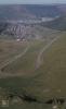
Picture: 1
Graig Fawr. Cwm Parc. Brown line of rushes where water drains from under tip material, February 1987
Date: February 1987
Picture: 2
East Rhondda Fawr, Tonypandy, Craig Fawr, Graig Fach watershed between Rhondda Ogmore and Afan. Cwm Parc
Summit junction of roads from Rhondda, Ogmore and Afan valleys. Above Cwmparc, 1985
Date: 1985
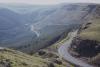
Picture: 3
East Rhondda Fawr, Tonypandy, Craig Fawr, Graig Fach watershed between Rhondda Ogmore and Afan. Cwm Parc
Road to Cwmparc and Treorchy from summit. July 1985
Date: July 1985
Picture: 4
East Rhondda Fawr, Tonypandy, Craig Fawr, Graig Fach watershed between Rhondda Ogmore and Afan. Cwm Parc
Head of Ogmore Vale Road to Blackmill from Treorchy
Date: 1985
Picture: 5
Cwmparc, Graig Fawr, Bwlch
Craig Fawr, Cwmparc. For sale 800 acres, February 1987
Date: February 1987
Picture: 6
Coalfield spare. Head of Rhondda Fawr/ Blaen Rhondda and summit
View from Graig Fach up the Rhondda to Treherbert Cwm Parc on right, 1985
Date: 1985

More items with these tags
Related items


Contact Us
To request take down or report racist, offensive or otherwise harmful content.

You must be logged in to leave a comment