Schematic Map of the Neath Canal
Description
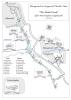
Attached you can find a schematic map of the Neath Canal from Pentrclwydau to Abernant canal Head, Glynneath.
The map shows the locks and bridges, along with the major houses in the locality at the time.
Resources and References:
Ordinance Survey Maps.
The Canals of the Welsh Valleys, and their tram roads, by D.D. & J.M Gladwin.

More items with these tags
Related items


Contact Us
To request take down or report racist, offensive or otherwise harmful content.

You must be logged in to leave a comment