Wales performed by John Speed
Description
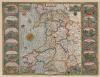
Shows Welsh counties and parts of adjoining English counties, including much of Herefordshire and Shropshire. Identifies towns, larger villages parish churches, rivers and diagramatic representation of higher hills and mountains. Compass rose in Irish Sea bearing the Arms of the Princes of Wales at its centre, the sea shaded to resemble watered silk in the style of Hondius. The sides of the maps are flanked by twelve views of the County Towns of Wales with smaller insets of the four Cathedral Cities of Bangor, St Asaph, Llandaff and St. David's set into each of the map's corners.
Text verso printed upside down on pages 99 and 100 of "The generall description, and severall divisions of the Principality of Wales." Sign Ggg....sold by John Sudbury and George Humble in Popes head allye - cum privilegio. 1610.
Artist: Speed, John, b.1552?-1629
Dimensions: 360 × 330 mm (14.17 × 12.99 in)
Scale (1:576,000)

More items with these tags


Contact Us
To request take down or report racist, offensive or otherwise harmful content.

You must be logged in to leave a comment