Prima Europe tabula (map) by Ptolemy
Description
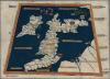
One of the earliest surviving copies of Ptolemy's 2nd century map of the British Isles. Originally published in Ptolemy's Geographia. This is the second issue of the 1482 map, also printed at Ulm, which was the first woodcut map of the British Isles and the first to be printed outside Italy.
Artist : Ptolemy, 2nd cent.
Dimensions: 350 × 500 mm (13.78 × 19.69 in)
External source:

More items with these tags


Contact Us
To request take down or report racist, offensive or otherwise harmful content.

You must be logged in to leave a comment