WAT'S DYKE E OF PADESWOOD
Description
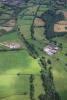
Aerial photograph of Wat's Dyke east of Padeswood, showing as a cropmark in a ploughed area, looking south-east. Taken on 30 July 2009.
External source:

More items with these tags
Related items


Contact Us
To request take down or report racist, offensive or otherwise harmful content.

You must be logged in to leave a comment